No, we do not have a buyer for the house yet. Our realtor says the weeks before and after Labor Day are the deadest couple of weeks in the year.
Craig and I have discussed staying in the RV vs. moving back into the house, and have decided to stay in the Alfa. Today I did the final sort and empty on several of the kitchen drawers. Not much to toss out since I have been culling thru it for so long. I ended up with a small pile of things to take up to the Alfa and a box of things to put down with the Yard Sale/Donate piles in the garage. I will continue to work thru the other drawers in the upcoming days.
Today, something "clicked" in my heart.
Today, I came to the final conclusion that I would never live in this house again.
Today, I became a full-time RVer.

At the Camel Farm, Julian CA
Saturday, August 31, 2013
Wednesday, August 28, 2013
Next Trip Planned Already!
We arrived home at the house early Tuesday afternoon. The cleaners really did a good job even if I think they were way overpriced. The cost was almost double what the realtor had estimated, and I had thought that was too much. Oh well, it is done, and between that and all the little things the realtor did with rearranging some of our furniture and adding accent items, the place looks as good as it is going to.
Craig was ready to move my cooking back down, but I said NO. We need to use the shower and laundry at the house, but I want to keep living in the Alfa for a while at least so the house stays "show ready".
He went to Camping World and bought an additional 50 foot, 30 amp extension cord. That along with the one we have and the cord from the Alfa just reach a 20 amp outlet. We have an adaptor for that. He said that if it looks like we will be here for a while, and he finishes the other jobs around the place, he will put in a 30 amp outlet there. But for now we have enough power to get by with if we don't need the air conditioning.
So, our only limitation will be the holding tanks.
With that in mind, we have planned our next trip for the 6th thru 8th of September. A three night stay in Marin county, just across the bay from San Francisco. The park isn't very attractive, pretty much just a gravel parking lot, and the space fee is very high, over $50 per night. But it is just a 10 minute walk to the Ferry. We want to go over to San Francisco Saturday and Sunday to watch the America's Cup races. Our Realtor is holding Open House on at least one of those days, so it gets us out of the way, and gives us an opportunity to dump. I would like to just keep going, but I have a mammogram appointment on the 9th. Yuck!
Funny thing happened to me on Tuesday. While we were hiking in the National Park, we kept seeing warning signs for yellow jacket ground nests. We were careful!

When we got home, we parked the Alfa in her usual spot, Craig went off to Camping World, and I gathered up a load of laundry to take down to the house. As I was walking down I felt a sharp pinch on my inner thigh. Ouch! I reached down and brushed off a yellow jacket that was stinging me.

I was baffled as to why it was stinging me, or where it had come from. Later when I went backup to where the Alfa was parked I saw dozens of them buzzing around several cracks and holes in the somewhat old asphalt driveway, no more than six feet from the rig.
I called Craig and told him to bring home some spray. I normally would let them be, but we can't avoid walking over them very easily and I don't want to get stung again!
I always said this property was like a National Park, but this is not a good similarity.
Sunday, August 25, 2013
The "Fun Part" is over for now
We left Oregon on Saturday morning, still tired from our dune adventure. It was a relief to spend the day driving! We take turns behind the wheel so neither of us gets worn out. We never rush to get out in the morning, so our 9:30 am departure was fine. We drove three hundred miles south to Redding California, and spent the night at the Win River Casino in their small but new RV parking area.
 They no longer allow free overnight parking, but the $24 fee was reasonable for the full hook-up pull-thru spot.
The quiet 13 spaces all have large level concrete pads, and good security. The overhead lights were a bit bright after so many nights in national parks.
We thought we might like to try the Sunday morning breakfast buffet at the Casino, but decided the $24 (plus tip and tax) per person was a bit more than we wanted to spend. Instead we had fresh baked almond croissants in the Alfa. We get them at Trader Joe's and try to keep a box on hand in the freezer for special mornings! They are so good!
Our Sunday drive was only 155 miles. We pulled into the Sacramento Truck Service parking lot shortly after noon. We had gotten permission to overnight here and were told the location of the one electrical hookup for an RV.

There were quite a few trucks around, but the only other RV was another Alfa.

Craig chose this place for our annual Freightliner service work because it had good reviews and recommendations on the Alfa Forum. We had the annual service work done in the LA area last year, but we won't be going down that way until Thanksgiving, and it's time now.
Its hard to believe this trip is almost over. We will be heading back to our house and getting back to work on the remaining repairs after the Alfa maintenance work is done. I had hoped we could head to the Sierras for a few days before going back, but with the fire in Yosemite it might be too smokey.
Oh well, at least the Alfa will get good service and be all ready to go full time!
Saturday, August 24, 2013
Re-Learning to See
This is one of the things I most appreciate about the photography on some of the blogs I follow.
Most of the images I include in my posts help tell my story. The following are a few of the little things I saw as we hiked thru the dunes on Friday.
 |
| Perfect little plants being buried in the sand |
 |
| Bird Bones |
 |
| The only flowers for a mile
Also, when Craig wrote about the thick brush we climbed thru, I don't think he really expressed how awful and tangled it was.

We went thru this kind of stuff and found ourselves somewhat lost and surrounded on all sides without a path to follow. Not a good time! When we did finally break thru and got to the beach there was no indication which way to go to find a way home.
Someday we will look back on this and remember it as an adventure. But for today, I'm just glad we managed to find our way.
|
Friday, August 23, 2013
Worst-marked trail anywhere
The following post only tells part of the story. We were VERY lost! Craig had to write it because I am dead tired.
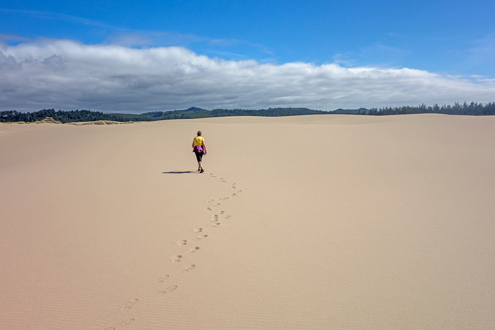
[From Craig] Friday we stayed in Lakeside, OR on the Pacific coast. Between the beaches and US 101 are many sand dunes, the Oregon Dunes. In the morning we looked for activities related to the beaches and dunes. First we visited the Umpqua Lighthouse which has a nice museum about the history of the area.
Then we went back to the John Dellenback Dunes Trailhead on 101, which is about a block north of the road that our RV park is on. While we've had less experience with hiking trails than many of our readers, we seriously want to nominate this trail for the "worst-marked anywhere in America".

Doesn't this map look simple? We think a sign said that the trail from the parking lot to the beach is 2.5 miles. The map is not to scale, but the trek across the dunes is probably about 1.5 miles. Trouble is, there are no trail markers on the dunes, and of course with wind constantly smoothing the sand surface, no worn trail can exist. So the problem is to navigate between 4 to 5 foot high posts with blue bands on top, on either side of a mile and a half of sand dunes.

Going to the ocean, at first we had lots of other hikers' footprints to guide us. But they kept diverging from each other, giving the idea that each party of hikers was supposed to find its own way.

We found ourselves confronted with a dense-looking band of bushes and trees between us and the beach. There was no hint of the trail, so we started trying to find our own way through, following the path of least resistance. But the resistance kept getting tougher, the trees kept getting more low branches to block our way, and the bushes kept getting scratchier and nastier.
It took at least an hour and lots of little path reversals before we finally broke through to the beach.

It was a fine beach, but no beach could be good enough to make the pain of getting there worthwhile. There was no sign of any human presence, activity, or markers, so we were faced with whether to go north or south along the beach, to find a way back that didn't involve crashing through dense brush and trees.
Merikay chose north, and after a mile or so, she was proven right. She found footprints on the beach leading to the trail through the band of woods. The first part of it was a nice boardwalk to help preserve the habitat. The rest of the way through the woods included some parts that were so overgrown and dark that one might have stumbled over Sasquatch if he happened to be sleeping on the path. A fascinating stretch of trail!

When we got back to the dunes there were several of the 4-5 foot posts with blue bands to show the way. We stood at the last one trying to see any more, but no luck. We recognized one hill with many coniferous trees that we had seen on the way to the beach, and headed south of it, more or less as our memory suggested.
Our memory sent us way too far south. When we got to the east side of the dunes we could find no trace of the trail marker we remembered, nor any footprints either! We oscillated north and south on the east side of the dunes, and all we could find that looked familiar was a river that was too large and deep to ford.

We were headed back north (the right way) but were getting really discouraged and short with each other when Merikay asked "do you have any bars on your phone?" There were, and we decided to try the pedestrian-guidance feature of the Navigation app on our Android smartphone. It has always done fine for our car and RV on roads, though we now use our Rand-McNally unit for RV guidance instead.
Our opinion of Google software went down when it didn't know about the trail. Then our opinion was crushed when the silly thing told us to proceed southeast on Sherry-Barbie Lane. We were at the east edge of the sand dunes with no roads in sight, with a river between us and all roads that we knew of. Including roads named after last-generation dolls!
Switched to Google Earth and hit "show my location". It showed Sherry-Barbie Lane between us and the river! We went in the indicated direction and found a small path that led to the road. Merikay got the sand out of her socks at an abandoned house on S-B Lane. It was for sale, hopefully for way less than our house.
Having found a road, Merikay was happy that our problems were over but Craig wasn't, because we still didn't know which way the trailhead was, so we didn't know which way to walk to our car. Walking along a nearby larger road that went under 101 without intersecting it, we asked several people where the trailhead was, but no one knew for sure. It may be that they and the Google software were confused by a recent name-change to "John Dellenback trail". Finally we walked about a mile north and found the trailhead and our car.
We may have walked 10 miles to "complete" a trail quoted as 5. We're both sore from the experience, and look forward to tomorrow as a day filled with driving rather than walking :-)
In the future, we're going to try the following things to avoid such problems:
Then with our compass and GPS apps (and the pictures) we should be able to get back to either such a trail marker or our starting point, remembering that in North America latitude increases going north and longitude increases going west.
Such steps seem so obvious after the adventure is over!
[From Craig] Friday we stayed in Lakeside, OR on the Pacific coast. Between the beaches and US 101 are many sand dunes, the Oregon Dunes. In the morning we looked for activities related to the beaches and dunes. First we visited the Umpqua Lighthouse which has a nice museum about the history of the area.
Then we went back to the John Dellenback Dunes Trailhead on 101, which is about a block north of the road that our RV park is on. While we've had less experience with hiking trails than many of our readers, we seriously want to nominate this trail for the "worst-marked anywhere in America".

Doesn't this map look simple? We think a sign said that the trail from the parking lot to the beach is 2.5 miles. The map is not to scale, but the trek across the dunes is probably about 1.5 miles. Trouble is, there are no trail markers on the dunes, and of course with wind constantly smoothing the sand surface, no worn trail can exist. So the problem is to navigate between 4 to 5 foot high posts with blue bands on top, on either side of a mile and a half of sand dunes.

Going to the ocean, at first we had lots of other hikers' footprints to guide us. But they kept diverging from each other, giving the idea that each party of hikers was supposed to find its own way.

We found ourselves confronted with a dense-looking band of bushes and trees between us and the beach. There was no hint of the trail, so we started trying to find our own way through, following the path of least resistance. But the resistance kept getting tougher, the trees kept getting more low branches to block our way, and the bushes kept getting scratchier and nastier.
It took at least an hour and lots of little path reversals before we finally broke through to the beach.

It was a fine beach, but no beach could be good enough to make the pain of getting there worthwhile. There was no sign of any human presence, activity, or markers, so we were faced with whether to go north or south along the beach, to find a way back that didn't involve crashing through dense brush and trees.
Merikay chose north, and after a mile or so, she was proven right. She found footprints on the beach leading to the trail through the band of woods. The first part of it was a nice boardwalk to help preserve the habitat. The rest of the way through the woods included some parts that were so overgrown and dark that one might have stumbled over Sasquatch if he happened to be sleeping on the path. A fascinating stretch of trail!

When we got back to the dunes there were several of the 4-5 foot posts with blue bands to show the way. We stood at the last one trying to see any more, but no luck. We recognized one hill with many coniferous trees that we had seen on the way to the beach, and headed south of it, more or less as our memory suggested.
Our memory sent us way too far south. When we got to the east side of the dunes we could find no trace of the trail marker we remembered, nor any footprints either! We oscillated north and south on the east side of the dunes, and all we could find that looked familiar was a river that was too large and deep to ford.
We were headed back north (the right way) but were getting really discouraged and short with each other when Merikay asked "do you have any bars on your phone?" There were, and we decided to try the pedestrian-guidance feature of the Navigation app on our Android smartphone. It has always done fine for our car and RV on roads, though we now use our Rand-McNally unit for RV guidance instead.
Our opinion of Google software went down when it didn't know about the trail. Then our opinion was crushed when the silly thing told us to proceed southeast on Sherry-Barbie Lane. We were at the east edge of the sand dunes with no roads in sight, with a river between us and all roads that we knew of. Including roads named after last-generation dolls!
Switched to Google Earth and hit "show my location". It showed Sherry-Barbie Lane between us and the river! We went in the indicated direction and found a small path that led to the road. Merikay got the sand out of her socks at an abandoned house on S-B Lane. It was for sale, hopefully for way less than our house.
Having found a road, Merikay was happy that our problems were over but Craig wasn't, because we still didn't know which way the trailhead was, so we didn't know which way to walk to our car. Walking along a nearby larger road that went under 101 without intersecting it, we asked several people where the trailhead was, but no one knew for sure. It may be that they and the Google software were confused by a recent name-change to "John Dellenback trail". Finally we walked about a mile north and found the trailhead and our car.
We may have walked 10 miles to "complete" a trail quoted as 5. We're both sore from the experience, and look forward to tomorrow as a day filled with driving rather than walking :-)
In the future, we're going to try the following things to avoid such problems:
- At the start of the trail, record the latitude and longitude from our smartphone GPS app, using paper or a note-taking app.
- If we come to a "last" trail marker that we may want to get back to, record its lat/long, and use our smartphone camera to shoot pictures of the marker from 50 feet away, then successively further away as seems might be useful.
Then with our compass and GPS apps (and the pictures) we should be able to get back to either such a trail marker or our starting point, remembering that in North America latitude increases going north and longitude increases going west.
Such steps seem so obvious after the adventure is over!
Wednesday, August 21, 2013
Good days
Monday was an odd day weather-wise. It was foggy when we got
up, but based on previous days we went off to the beaches after breakfast
anyway. Got there, sat in the car watching the rain pour down for a while, and
returned to the campground. After lunch
in the Alfa, Craig took a nap and I did some needlepoint. It finally cleared
later in the afternoon and we took a short walk, but otherwise we just relaxed
for the day. It was very peaceful.
Tuesday morning was clear and sunny again. We took the
rather short but beautiful hike up to Merrymere Falls

and the Moments in
Time trail. We parked near the Crescent Lake Lodge. While not as grand
as the Ahwanee or the lodges at Grand Canyon and Crater Lake, it is cited in of
a book of lodges in the National Parks. Like most of the others it was built in
the thirties and has the air of “old time character” we have enjoyed visiting
them.

Following our tradition of eating at the Lodge at least once
during our visit to a National Park, we had lunch in the dining room
overlooking the lake.
This was our view from our table by the window, but Craig
actually took it outside.

How quickly our time here has passed. Tomorrow we will pack
up and head out seeking our next adventure. I’ve had time to relax and think
about a few things. Time to take a deep breath and re-examine “my plan” and “my
view” of the future.
Craig and I have been married for 47 years. Our best times have been when we were on
trips away from the daily stresses of house and job. I know that full time RVing is not full time
vacationing, but I’m looking forward to some fun adventures and some quiet
peaceful days. We have overcome many
challenges together over the years. I am confident we will overcome more
together in the future. But I also know we have to relax and learn to have more
fun. I believe we will.
[From Craig] Merikay has asked me to write about Wednesday.
We got out of Sol Duc reasonably early for us (9:45), and headed south on the
101 loop that encircles the Olympic National Park. We took the Alfa in on the
road to the Hoh Rainforest. Those of you who are very experienced in RV driving
will have no problem with the road in, but those who don’t care for “interesting
driving” may want to leave your rig somewhere outside and take your smaller
vehicle in.
Actually the Hoh Rainforest site has nice big parking spaces
for RVs. We left ours in one, had lunch on one of their tables, and then went
hiking on two fairly short trails.
The Hall of Mosses trail is unique in my experience. At just about any point on this 0.8-mile
trail, you can point your camera in just about any direction and shoot a
terrific picture! No photographic skill required! Just look at the following
images for proof.
 |
| Green! and more ... |
 |
Green! |
The Spruce Nature trail is another fine adventure in
learning about non-tropical rain forests. At one point I said to Merikay “I
wonder what this looked like before they spruced it up?”
 |
| Giant "Pick Up Sticks" |
 |
| Finding your Roots |
Getting back to our rig, we re-coupled the Alfa and toad and
headed back out to 101. We had no idea where we were going, but Merikay perused
our various resources and selected Kalaloch Campground in the coastal part of Olympic National
Park. It has 170 RV sites "on the beach" but no hookups.
When we got there, there was no one at the office but a sign
“no spots available” was displayed. I stayed with the Alfa while Merikay walked
down the RV sites and couldn’t find any flagged as available. About the time
she got back, a ranger arrived and confirmed that he didn’t know of any
available spots. But Merikay said that what she saw of the place was very nice,
and it’s worth a stop (or a reservation if you have Internet access like we
haven’t had for a week) if you get up into western Washington. With 170 sites it can’t be full all the time!
We continued south and ended up finding a spot at the Hoquiam River Rv Park. We found it thru our Rand McNally Navigation unit, and also in our Escapee resource book. Nice park, good people. Good internet connection! LAUNDRY! Which we did need.
Who knows where we will be tomorrow night. The open road beckons. And this RV park is fully booked so we have no choice but to move along.
Tuesday, August 20, 2013
MLS and Virtual Tour
Well, our house is finally listed on the MLS. The agent had an open house this
weekend. We have decided to not blog
about the process until it is done, closed, and money in the bank.
When we return from this trip, we will still have some minor
fixing up to do as a result of the inspections, and we will be working hard to
get rid of all the stuff we still have. That I will post about!
This is the link to the Virtual Tour our realtor did for us.
I know it is meant to be only a quick peek, I think it misses a few important
features, but hopefully it will help bring in some potential buyers who will
fall in love with the place.
Keep your fingers crossed for us.
As I have written for many others “It only takes one buyer,
the right one!”
Monday, August 19, 2013
Olympic National Park, three day update
Friday, August 16, 2013
It is somewhat hard to believe the rest of the world exists.
It certainly doesn’t feel like it’s August.
There was a question about some of the distances. Sol Duc
Hot Springs is 12 miles from Hwy 101 and then Port Angeles is another 30 miles
to the east, and Forks is 28 miles to the west. There are at least two rain forests,
one is another 32 miles past Forks, and the second is another 69 miles. It is a
big park and nothing is a quick drive.
Since it was bright and sunny, Friday morning seemed like a
good day to hike the high country at Hurricane Ridge.


I once dreamed of hiking in our beautiful
National parks, and now I am doing it!
How different this was from the hike thru the forest to Sol
Duc Falls. At one point I felt like I was on the set for The Sound of Music.
You know, the scene where Julie Andrews burst out singing “The hills are alive
with the sound of music…”


Every direction you looked the view was breathtaking. Every moment it
seemed the light changed. The hike was a bit hard, but the sights were very much worth
it!
At the top of Hurricane Hill a very tame deer was busily
eating the tips of the highest evergreen tree there. I could have reached out
and petted her, but of course I didn’t because the rule is to keep the wild,
wild.


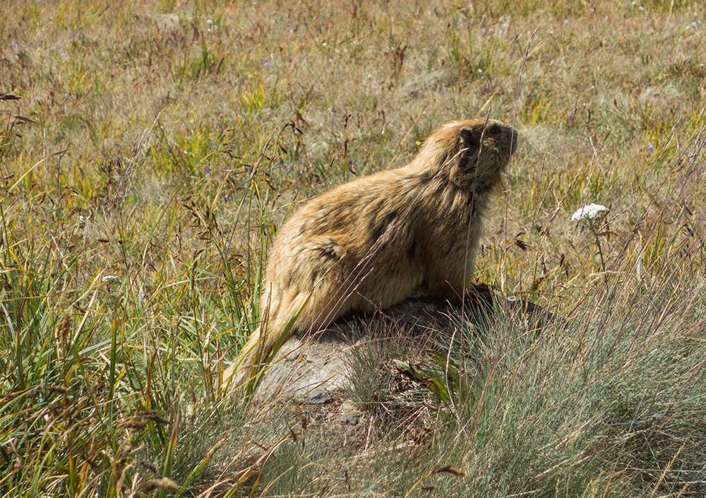
We also saw this furry guy. He is an Olympic Marmot. He was
close to the trail, didn’t seem afraid of us, but kept his back to us so he
could make a quick get away if necessary.
I thought he looked like a very fat, fluffy cat crossed with a giant
prairie dog.

After dinner we soothed our tired hiking bodies with a nice
soak in the mineral hot tubs at the resort. They do charge a bit extra unless
you are a guest at the resort itself, but we got a double discount. The cost
was only $6.00 each because we are seniors and we went after 7 PM. That still
gave us plenty of time for an hour-long soak and a shower before they closed
for the night.
I don’t think I would want to go in the hot tubs and then
drive to a distant campground outside of the park, but it sure was relaxing and
the walk to the RV only took a few moments. The last number I saw on the clock
before falling asleep was 9:44. Snore!
Saturday, August 17, 2013
We are starting to understand the weather patterns
here. We woke to a very dark foggy world
Saturday morning. That was fine because
our plan for the day was to drive out to Neah Bay, stop at the Makah Indian
Museum and then go to Cape Flattery for a for a short walk.
The drive was quite scenic, and we stopped in Sekiu for a
brief look at the boats moored there. They were having a salmon fishing derby
for the kids. Everyone was walking around with a large fish in hand! I guess
they had to check in their fish for the completion. The town itself seemed very “real”, in that
it was not a cutesy tourist spot.
We bought our $10 parking permit at the Makah Museum and
went out to the Cape. Although it was just after noon, the sky was still
overcast and wisps of fog filtered thru the trees. The forest was wet, but not
dripping.


The path from the parking area to the sea overlook was wet
and mucky but not slippery. Much of it
was boardwalk, with many steps up and down.


The view of the cape was intriguing.


It was not much
different than many other rocky cliff overlooks we have seen, but somehow
knowing it was the farthest-northwest point of the continental United States
made it special.


Sunday, August 18, 2013
Forgot to grab the camera today.
We went on another six mile hike in the Elwah River area. It
was mostly forested, with some great views of the river. At one point as we
walked along a winding path, thru a fern and moss covered, sun dappled, grove,
Craig said he felt like he was in a Disney movie, and that any moment a group
of dwarves might appear singing “Hi Ho, Hi Ho …” Quite a place!
[From Craig] Every
morning this week in Western Washington it has been cloudy and sometimes drizzled.
But one must not give into despair and just plan to read all day, because it
typically clears by 11. Sunday we forgot the camera. The Elwha valley had lots
of very tall firs, some amazingly thin for their height. We will have to call
up our visual memories, while you will have to go to other blogs for your daily
fix of nature images. Sorry.
Monday ... Off to see some Beaches.
Monday ... Off to see some Beaches.
Subscribe to:
Posts (Atom)