Tuesday, May 12, 2015

Hiking North Zion, Kolob Canyons - Taylor Creek Trail

First a couple of responses to comments.  You are right Doug, there is no pool at Red Canyon RV. I must have confused it with some other place I had considered. It is just a two road lot with a few cabins on the side of Utah Highway 12. But it is convenient to Bryce and a few other places we want to visit this week.

And to Judy, yes I do want to do a day trip to Kodachrome Basin this week.

The weather was fine for another hike on Sunday, and we headed over to the North part of Zion that not as many people seem to visit.


There we hiked up the middle fork of Taylor Creek to the Double Arch Alcove. I forgot my camera, so the few pictures included here were taken with Craig's phone.

In one of my books, and in the information from the park, the hike was supposed to be an easy five mile round trip. In part because we went astray at the start, our "Map My Hike" app read just shy of six.  

Easy it was not! The trail was littered with large jagged rocks that were definitely hard on my ankle. 


We crossed Taylor Creek, which was only inches deep in most places, about 120 times (60 each way).

All of the crossings were easy, but I was careful to use my poles so I didn't misstep.


Once again we were treated to impressive views of red rock canyon walls, some with water flowing on them.

When we got back to the Alfa in the late afternoon, I flopped down on the bed for a nice 40 minute rest. Craig took off my hiking boots for me because I really didn't feel like moving. I was very glad we had yummy leftover pulled pork that I had made the day before for dinner. I don't think I would have had the energy to cook a meal.

My entire being was tired. But it was a good tired. The kind you feel after doing a hard job, skiing all day, or running a race. I felt at peace with myself and with the world. That is in part why I hike. I enjoy the scenery, and know the exercise is good for me, but I really like the satisfaction I feel. I could never get this good a workout in a gym.

[From Craig] Merikay didn't like the two pictures below as well as I did.  This first one is inside the inner of the two arches at the end of the trail.  All those colors are different minerals that have seeped through the big rock above over the millenia.  I wish I had taken more chemistry and/or geology so that I could tell you which color is which compound.  If anyone reading knows, please leave a comment or send me an email at craigm014@gmail.com.


The second image shows two attractive rocks that stand together on the north side of the canyon.  I like to think of them as brothers who have watched animals and people walk past them over the years, and share a constant but low-bandwidth commentary about the travelers.


We will be hiking past a lot of rock formations in the next few months.  Where are your favorites located?

Sunday, May 10, 2015

Just Livin', a week at Sand Hollow State Park, Utah

I love the sky. 

One of the things I missed in my world during the last ten years or so of our living in our home in the Santa Cruz Mountains in California, was a big sky. The way the house was situated the view of the sky was always limited by the trees.

Sunset at Sand Hollow

At Sand Hollow we had a magnificent, 360° view of the sky. 

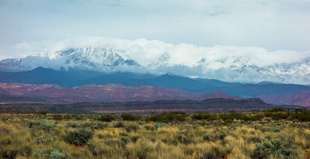
There was open grass and scrub covered landscape between us and the distant mountains on three sides. 


And a large cinder berm that edged a reservoir on the fourth.


Most of our days here were slightly cool, and one morning we woke to the view of snow on the largest mountain.

In addition to our hikes, we have had some very pleasant, long sleepy afternoons, where we did nothing more than curl up with our books and watch the clouds come and go.


One afternoon we took a drive around the reservoir to where there are a lot of off road trails.  Craig wanted to go "Jeeping", but I wasn't enthusiastic. 


We compromised with a drive around on the hard sand beach.  
All in all it has been a very peaceful week here in Hurricane, Utah. I really do love State Parks. If the weather permits we plan on hiking in Zion again on Sunday.

We travel on Monday, and are headed to Bryce Canyon National Park. As far as I could tell, neither of the campgrounds in the park have electric or water hook ups, so I made reservations at a commercial resort called the Red Canyon RV Park in Panguitch, Utah. 

I hope the pool is nice. 

Friday, May 8, 2015

Angels Landing: we're still alive!

Well, so much for sticking to the easy hikes until my ankle is completely healed! On Wednesday evening, in a fit of madness, I declared that I wanted to hike Angels Landing in Zion National Park.  It's the among most popular hikes in the National Park System, and among the least-frequently completed.  I figure with my increasing age and deterioration of my body, if I didn't hike it this time, I would probably never hike it.


With a bit of trepidation, Craig agreed and it became the planned adventure for Thursday. He then read (aloud) some of the reviews of the hike including ones that mentioned the fact that six people have fallen to their deaths from the narrow rock ledges that comprise the last 1/4 mile of the hike, 1400 feet above the canyon floor, where you have to cling onto chains that are anchored into the rock to make your way along.

By Thursday morning I was no longer quite sure I wanted to do it, but we went anyway. I too had read some things about the hike, and figured I could always turn back if things got too hard. 

When we were at Horseshoe Bend, a nice man suggested I get rubber tips for my poles because they didn't slip on rock, so on the way into Zion we stopped at not one, but three different sports equipment shops looking for tips. At the first two I also talked to the guys behind the counter about Angels Landing. They assured me that although the first two and a quarter miles were "a real Huff and Puff", if you took your time it was do-able. I was also informed that many people stopped at a place called Scouts Lookout, which is just below the chains. This info gave me enough confidence to "give it a go"!

You can see hikers in the lower left corner of this image
The first part of the trail is a very easy stroll along the edge of the river, but the goal looms high overhead. Are we really going to go to the top of that?


The Huff and Puff started gradually, with long but uphill sections of trail. But these and the much steeper switchbacks ahead were easy to walk, because they were all paved with either sidewalk-like cement or a more textured hard surface. Much easier than loose or irregular rocks and roots.

Here you can see the trail winding slowly upward. The rocks at the bottom of the picture were at the edge of a sharp dropoff, overlooking the previous switchback. 


Here's another view...


We just kept going up, resting at most switchbacks.


Going up, my ankle didn't bother me very much. Catching my breath was another matter! I sure wish I were 50 or 60 pounds lighter.

Up... up... up... beautiful views! The weather was perfect for this hike: in the low seventies with just a bit of a breeze.


Eventually we got to the part of the trail called "the Wiggles." It consists of 22 or more short but steep switchbacks. The image above shows five of them. 


Just about the time you feel they will never end, the trail spills out onto a fairly large, fairly flat sandy area called Scouts Lookout.

This is where people decide if they want to climb the last quarter-mile up the rocks on the right side of this picture.  Which leads to its informal name "Chickens' Landing".

We had our picnic lunch and I stayed there while Craig bravely went about halfway up the chains. 


He said he had to turn back when he couldn't quite see where the trail went next, and couldn't bring himself to trust the designers of the trail. I held my breath as I watched him come back down.

I did not get a picture of him because he had the camera.  This is a shot of some of the other hikers. Strange how you can never quite show how steep something is in a picture, nor the fact that this rock edge overlooks a 1400 foot drop off!


The walk down had its own difficulties. Breathing was no longer a challenge, but the downhill angle was hard on our knees and my ankle. Although the stops were not as frequent, we did stop to rest from time to time.


It was a beautiful day! We both felt good because we had done (most of) it! For me, stopping at Scouts Landing was still a victory. 

Needless to say, Friday was a rest day.

Wednesday, May 6, 2015

A Hike in Snow Canyon

After a rainy night, the weather at Sandy Hollow State Park was just about perfect for a nice hike. The forecast was for temperatures in the 70s with partly cloudy skies. The ankle I sprained in early March has been getting better slowly, but it is still not 100%, and I am trying not to overdo. I wear a pressure bandage and good hiking boots whenever I have to walk for any length of time.

Although I try to limit the number of books we carry, I couldn't pass up "Hiking the Southwest's Canyons" by Sandra Hintchman. I think it will come in very handy for finding just the right hikes for us. Tuesday was the first time I have used it and found the perfect place for us to start our Red Rock May. 

Snow Canyon State park is near St. George, Utah. The book gave pretty good descriptions of the short hikes I selected: Butterfly Trail which connected with Lava Cave Trail for a little over a two mile total distance. I could probably do three with no significant pain, but I want to work into it slowly. 


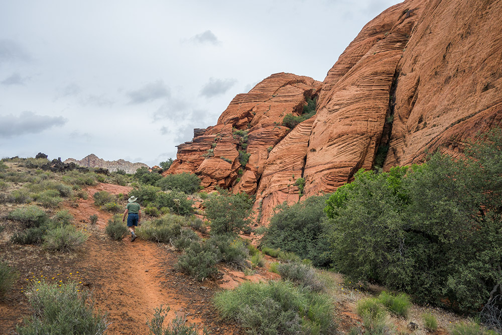
We started on the trail, and made the correct first turn, but then were distracted by this wonderful swirly rock formation. In a sandy area it can be easy to lose the trail, and since the sand was wet from the previous nights rain, other people's footprints showed up quite well. 

We followed the footprints and lost the official trail.


But then we came to an area of slide rock where there were neither foot prints nor any trail markers.


Craig started to climb up this petrified dune, but I didn't agree that that was the way to go. We consulted the map and were even more confused because the line on the map seemed to be going over the swirly sandstone formation. I wasn't sure about that because the Butterfly Trail was marked as an "easy" hike. Then, I spotted a trail about 40 feet down the hill that was going in the right direction too.  But how to get to it?

As we backtracked to the last marker we had seen, we noticed footprints in the sand going many different ways. It looked like a lot of people had been confused.

The trail description in the book says the trail goes down a reddish Navajo Sandstone Slope. We found it.


 The upright in the center on top is a trail marker. There was a matching one at the bottom, so we knew we were going the correct way. It looks harder than it was. Although they were rounded and irregular, the ridges in the sandstone were like cut steps, and I was glad I had my hiking poles for balance. 


Once down, the trail became very nice. There were not many people on the trail, but we did pass a group of teenagers going in the opposite direction. They warned us about a rattlesnake on the trail. We didn't see it, and assumed the gaggle of rambling guys had scared it off.

About halfway through our hike the Butterfly Trail ended and we continued along the Lava Tubes trail.


The black, rough lava rock was a contrast from the wind-carved red, yellow, and white sandstone. There were several lava tubes in the area, but we didn't feel inclined to explore them.


The sandy floor of the canyon was covered by lush green mountain sage, creosote bush, hearty grasses, and blooming wild flowers. Cactus plants were far and few between. The red rock walls of the canyon were immense, and rival similar formations we saw in Sedona.

The trail brought us back to the road, and we completed the loop back to our Jeep with a nice, easy, downhill road walk. Before heading back to Hurricane, we found a picnic table to sit at and enjoy our lunch sandwiches.  Smoked trout!

Snow Canyon State Park does have a RV campground with full hook-ups. We drove by it and saw a couple of large Class As and fifth wheels. I am going to put it on my list of wonderful places to camp, and if we ever come back this way, we will try to get a space.

Finally, a bit of trivia: this canyon was the site of the Hollywood movies Butch Cassidy and the Sundance Kid, The Electric Horseman, and Jeremiah Johnson.

Don't miss it if you are in the area.

Tuesday, May 5, 2015

Turning Page and into Hurricane


We decided to go out for a Mexican dinner on our last night in Arizona. Craig fit right in wearing his favorite German shirt.

[From Craig]  Many years ago I drove into a medium-sized shopping center in San José that I had never visited before.  A store called European Men's Warehouse was having a going-out-of-business sale.  One big table had lots of very colorful shirts on it.  I read the labels and found that they were all cotton and made in Germany.  The price tags showed a long saga of markdowns: originally $125 each, marked down to $35, then $20, $12, $5, and finally 2 for $5.  That's 2% of the original price!  Needless to say I bought one of every design they had, plus a couple more in a larger size for our son.  He liked them so much he gave them back to me, which was a good thing because I grew larger as I got older.  

They only one left is shown below.  I mostly wear it to Mexican restaurants.


Being retired people we tend to eat out early. When we returned to the coach, the sun was just setting:


And, the moon was just rising:


Next stop, (B on map)
           147 miles,
                Sand Hollow State Park,               
                                    Hurricane, Utah

Sunday, May 3, 2015

Nature's Eye Candy, a return to Antelope Canyon

Nature's Eye Candy
Long-time readers may remember that we visited Lower Antelope Canyon in October of 2013.  We were on a trip to Zion National Park, and because of the government shutdown were not able to hike there. We knew that Antelope Canyon was about a hundred miles away in Page, and since it too was on our "bucket list" we drove over and toured the lower canyon. Now, on our return to Page, we decided to visit the upper canyon. 

I sometimes forget that not everyone who sees my blog posts has been a reader for a long time, and may not know the names and locations of the places I mention. Five years ago if someone mentioned Page, Arizona, I would not have known were it was either.  So, here is a little map. 


Some places deserve more than one stop!

In 2013 at the lower canyon, we just showed up, paid our fee, and waited for the next tour group of about 20 people plus a guide. This time we choose to make a reservation for an 11AM "prime light time" tour of the upper canyon. Two hour "Photography" tours are also offered for which everyone must have a DSLR and a tripod, and your guide will show you where the best shots are, and keep the crowds from passing in front of you.


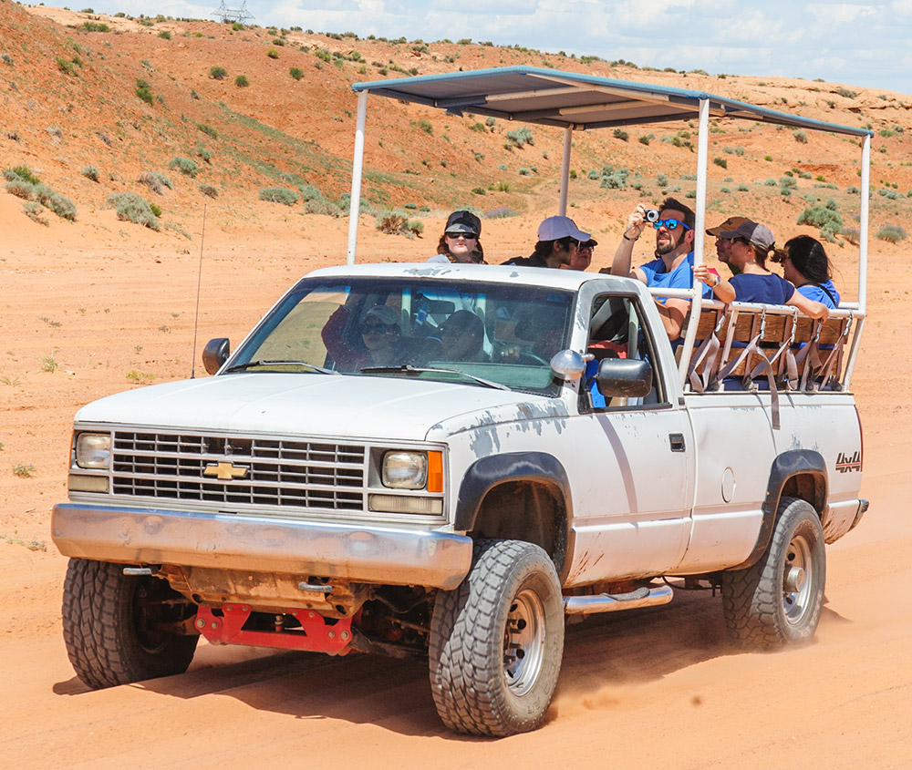
We arrived at the parking area, signed in and paid our fees, waited for a little while, and boarded our assigned truck along with 14 other people. Our guide was the driver, and along with a number of other open trucks, we were given a dusty, bumpy ride to the canyon entrance.

A word about the crowds: you cannot go into either Upper or Lower Antelope Canyons without a Navajo guide. You can only get a Navajo guide through one of five companies. Because the canyons have been featured in ads on the Super Bowl and in every guide book and magazine about this area, the demand is very high.  In other words, you are shoulder to shoulder with other people most of the time.


But as you can see from this picture of Craig leaving the canyon, it is a lot taller than a person, so even if you are jammed in on all sides by other photographers, the beauty above is not compromised, and you can get some great images by shooting over everyone's head.

There are a number of other slot canyons in Arizona and Utah, and we hope to be able to explore one that is not as busy as Antelope in the upcoming month. I did consider a day trip to Buckskin Gulch, but even the easiest way in involved a two mile hike (one way) and rock climbing down an 8-10 foot drop-off to get into the canyon. It seemed a little more than I am up to at this point in my life. It is also on the list of the ten most dangerous hikes in the US, because of the danger of flash flooding.

Enough about a hike we didn't do. On this day, we took over two hundred pictures.  Here are a few we have chosen to share:


When the wind blows, sand filters down from above, and during "prime time" the sun shines down to create a number of spotlight effects.


You can easily imagine the swirling water as it carved through the sandstone canyon.
Looking Up

Later in the day these beams of sunlight will be gone.


If you Google "Antelope Canyon" and choose "Images" from the top bar, you can see hundreds of pictures of the canyon walls. But if you can, go see it yourself. Just ignore the crowd and look up!


Friday, May 1, 2015

Bucket List and Bust


First the bust: sometimes the world doesn't cooperate with my time table.  I had it all planned. We would drive down to see the North Rim of the Grand Canyon from our RV spot in Page AZ.  A nice day trip! But, the world isn't cooperating, in that the road to the North Rim is still closed. That part of the park will not open until May 15th.  Oh well, a good reason to come back another time.

However, Thursday I checked off a big one on my must-see bucket list. About 25 years ago, Craig bought a beautiful, large format photo of a river winding around a huge stone formation: a U-shaped bend in the river. Eventually I learned it was a place called Horseshoe Bend. But I had never really researched exactly where it was. When the picture hung in our home in California, I would sometimes look at it and promise myself that someday I would go there. It may have been one of the items that helped stir my desire to RV full-time.

Well, as we drove into Page from Flagstaff on Wednesday, I saw a brown sign along US 89 indicating that a turn-off for Horseshoe Bend Overlook was ahead. Could it really be the same place?

That evening I Googled it, and yes it was. It is located only a few miles south of Page. Going there became our Thursday afternoon expedition.

The turn-off went to a large parking area just off the highway. The path to the overlook was 3/4 mile and consisted of a relatively short, steep uphill climb, followed by a long, not-too-steep downhill walk. But as we were going down, I reminded myself that we would have to climb back up it again!


If you look carefully you can see some people on the path to the overlook (on the lower right). They give a sense of how big the canyon is. You can't see the river until you get to the rim.

Although there were a lot of people there, I wouldn't say it was overcrowded. My friend Al would probably not agree. There were times when I had wait a few minutes for someone to move out of the picture I was going to take, or wait to climb onto a rock that offered a bit better vantage point, but in general the people were all nice and everyone seemed quite respectful of the place and of each other. In fact we rather enjoyed chatting with several people, sharing stories and appreciating our mutual luck to be there on such a fine day.


Once you arrived at the rim there really wasn't much to do except look, people watch, and take picture after picture of this amazing place. We did walk along the rim for a ways, but mostly stayed where most of the people were. 

Another nice thing was the frequency with which people offered to take pictures of each other, using the subject's camera.  
[From Craig] In the case of the two images below, there was the added factor that a pretty young female tends to make men really helpful :-)


Don't get too close to that edge.


That's better!

We each took many pictures, using both of our cameras. This was the closest either of us came to getting the full width of the river and the top of the rock formation.


At one point during the afternoon we spotted a boat coming around the bend. In this zoomed-in image you can also see a tiny boat mored at the shore and part of a campsite canopy tent.

It is so hard to limit the number of images I include in a post about a place like this. My main criteria for inclusion is that the picture should help tell the story. But here are a few more that are just "special".


So,  until next time ...