Friday, August 28, 2020

Last Full Week in Bandon, Oregon

 On Sunday we walked 4.91 miles!


I wanted to go back and have a picnic under the tree mentioned in my last post, so on Sunday we picked up some Subway sandwiches, parked the Jeep near the tree and set out to walk to the Bandon Lighthouse.  

I didn't realize how far it was!


The path was smooth and paved for about a mile. We then got to the beach access and had to walk along the side of the road for another mile and a half to get to the lighthouse.


We could have gone down onto the beach, but it was very windy.

When we got back to the car, someone else was using the table, so we went to another table and had our picnic anyway.


The next day Craig went to Eugene for something. On the way he went through a small town named Drain. 

When you are retired, I guess you have time to stop and take pictures of signs along your way. 


 Thursday

Simpson Loop Trail in Point Arago State Park


When we first arrived in Bandon, I did a bit of research and made note of several inviting hikes. We have done all of the "Easy" ones that were at least two miles, and I had one more on the list, the Simpson Reef Loop Trail. Listed at 3.2 miles, I didn't really notice the "moderate" rating.


Starting just across from the Simpson Reef Overlook, the trail was pleasantly level and wound its way through lush ground cover. But it quickly turned into a rather steep climbing trail. If you look closely at the right hand image, you can see Craig amidst some large ferns.

In many places there were more roots than trail, and I had to watch my step to avoid tripping. The trail just kept going up, up, and up. I noted later the elevation change was listed at 610 feet. (OMG! That is equal to a 61 story building.) We felt we had made it to the highest point after about a mile and started going back down. But this turned out to be going down to a creek bed before going back up again. 

Eventually we did start back down, and that proved to be a bit bothersome to my old knees.  Benches were nonexistent, and even suitable logs or stumps to rest on were far and few between.

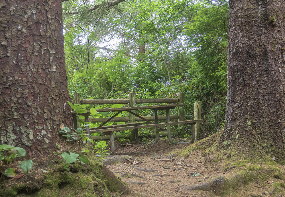
Just as my legs were screaming, my knees ached with each downhill step, and I wondered about my sanity for choosing this hike without thinking about what "moderate" meant, we spotted a picnic table tucked in behind two very large trees. 

Wishes can come true. We stopped, ate our sandwiches, and rested a bit before going on. 

A little further on, we spotted a strange, colorful, ruin just downhill from the trail. We could see it was built out of concrete blocks, and was made up of several roofless rooms.


We went on, and came to a short path that led to it. It was very strange in that it was covered with many layers of graffiti, most of which was not "nice", and at the same time the floors were clean of anything other than forest debris. I would have expected the sexually frustrated taggers would have left it full of empty beer cans etc. Perhaps the Park Service cleans it out from time to time.


Later, thanks to Google, we learned it was an abandoned  WW2 bunker. 

The forest part of our hike was almost done. 


This had to be the most tortured tree we have ever seen. But in an area with an ocean inlet named "Devil's Kitchen" and a road called "Seven Devils", perhaps this was the "Devil's Tree."
 

Once it crossed the road, the trail became much easier as we hiked along the top of the cliffs overlooking the sea.

 The views were breathtaking.


We finally made it back to our starting point at the Simpson Reef Overlook. At the start of our hike, the fog was thick and we could not see the water below. But we could hear a lot of seals barking in the distance. If you look just below the largest rock in the image above you can see a small beach packed with seals. This is about how we could see them with the naked eye.

But, thanks to the power of a 600 mm zoom lens, the scene looked like Miami Beach before COVID-19.

 
Needless to say, I was wiped out and took a nice nap when we got back to the Alfa. We will be in Bandon for a couple more days, but I think this was our last planned hike. But, as I write this the next day, I feel fine and I am wondering what easier hikes we can find around Port Orford next week.

(Steps today = 11,782)


Thursday, August 20, 2020

Fifty Shades of Green - More walks in Bandon Oregon Area

Tuesday we hiked the last three miles of trails at the National Estuarine Research Reserve.

There is a theory that many of your feelings or reactions today are a result of something that happened to you at an earlier time, and that by understanding your past, you better understand your present. I don't agree with this 100%, but wonder if my love for green places such as parks and forest is a reflection of the joy and freedom I felt while playing in a small wood lot near my home when I was in second through fourth grade.

It was part of a old farmstead that had been donated for a park but not yet developed. There was a large pond, a creek, and a wooded area that was quite overgrown. 

Sixty plus years ago it was safe for a little girl to play in the woods by herself. It was my imaginary kingdom. I remember pretending I was a pioneer. It was were I learned to love nature. 

Most of the time I went there alone, and if other children were around, we avoided each other! 

I remember some boys had a tree house in the woods. Not the kind you can buy at Lowe's for $1000. Theirs was made with scraps of old lumber. They built it themselves, and no girls were ever allowed. 

Hours spent "in the woods" were some of my happiest. And now, although I suffer from the aches and pains of age, a walk in the woods remains one of my favorite activities. 

I feel like I have come full circle so to speak. But now I have a nice boy to share the woods with.

The large old growth trees of the Estuary land were logged out in the past. Some of the old stumps are still there.


On the drive back to Bandon, we stopped at a place where you get a pretty good view of land that is being logged.

From Beaver Hill Road, the many stages of destruction and renewal can be seen. From clear cut to full grown forest, each its own shade of green. As much as I love the forest, I realize it is a resource. Trees harvested for lumber are a crop. I'm just glad they set aside some for recreational hikers like us.

Thursday we went hiking at Bullard's Beach State Park, starting at their "horse camp".


The first mile of our hike was on a soft sand equestrian trail. It wasn't really hard, but I count it as a mile and a half because of the sand!

By taking the right turnoff, we came out into the regular RV camping area. From there we walked a very civilized asphalt path along the road back to the Horse Camp where we had started. Another three mile day. 


The Coquille River, flowing to the ocean, separates the park from Bandon. It was just across the road from the path we walked.

This would be a great place for a picnic, under a really great tree!

 Maybe we will bring lunch here next week when we come for a walk to the lighthouse.

Me

Sunday, August 16, 2020

Walking in John Topits Park in Coos Bay Oregon

A short post

I wrote this on Saturday. We are taking a few days rest from hiking, in part because I started to develop a blister on one of my toes and want it to heal before hiking more. I have type 2 diabetes and have to be very careful about foot injuries. Even little ones.

On Friday we drove about 30 miles north to Coos Bay, where we took a very nice 3.3 mile hike along the meandering paths of John Topits park.


When Craig saw the park map he said we were about to "hike around an elephant".

It was his turn to be the photographer. Each of our cameras has unique characteristics, and each of us sees different things. He took about 100 pictures on our walk, and here are just a few of them:

The paths go along the edge of one small lake and around another.


There was a good mix of deciduous trees and evergreens. The ground cover was natural but not overgrown.


Some of the lake waters were quite open, but this section had a stand of old, dead trees and stumps.

I wondered what the story was about this bridge. Broken at both ends, it stands in a shallow part of the lake.

The bridge is visible on the right side of this picture. It must have been a way to get to this island. 

This picture was taken at the shore near the island above. The water was shallow and still. There were no trees above so it didn't seem like these could have fallen into the water from the land. There were water lilies across the lake, but there were none above water near this stuff. I can't find anything like it on the internet. 


Does anyone know what these are?


Thursday, August 13, 2020

Walk around Bandon and another hike at the Slough

Several people told me to be sure to get an ice cream cone at the Face Rock Creamery in Bandon.

Wednesday we parked at the other end of the Old Town area and walked 3/4 mile for a treat. It was indeed wonderful ice cream, and the double cone was a very generous size.


Old Town Bandon isn't much to get excited about. Lots of small restaurants that were either closed or serving outdoors, and the usual selection of craft, gift, candy and fudge shops.

Just about everyone we passed on the streets was wearing a mask, and all stores had signs requiring masks for entry. Nobody was making a big deal about it. Perhaps this is why this county has zero COVID deaths even with the tourists that pass through.

This large fish was one of several sculptures on display. It was made of trash from the ocean.

On Thursday we went back up to the Estuary and hiked another 2.5 mile section of the trails (marked in red below).

This place is a showcase of nature.


Most of the trees were second growth, but this giant cedar may have been one of the few that survived the original logging of this area.


I wish I could share the sounds with you. The wind was whispering in the trees, a few birds were singing, and the gentle babbling of the Hidden Creek were soothing to the soul.

The trail took us down along the slough, where the water was at low tide.

When you first look at the image below, what do you see?

I saw Bigfoot with a peg leg. 

Towards the end of a hike, I find myself looking down as much as up or ahead. As I tire, I try to be more careful of where I step so I don't stumble. I also try to "see" the small and beautiful things along the way.

There were a few other hikers on the trails today, but I may have been the only person in the world to have noticed these treasures.

I am one lucky lady!


Tuesday, August 11, 2020

New Week - South Slough

We had a nice weekend doing errands and resting. We met another Alfa couple, who were a couple of sites from us,  and spent Sunday afternoon sitting out in the sunshine and chatting. (Social distance maintained.)

On Monday we were going to go on another beach hike, but were turned back by very cold wind. We did log about 1/2 mile.


On Tuesday we found the perfect trail!

Beautifully wooded and challenging at the same time.


The South Slough, part of the National Estuarine Research Reserve, is about 20 miles from our RV park.

The available trail system seems to cover about ten miles of paths. We did the trail marked in yellow above.  It was a little over two miles. In the near future we will be returning to do parts of the remaining trails.

Some pictures from our hike:


A tunnel through the forest.


Bench.


We were amused by this "stump chair" on the side of the trail on our way down. We often take a few minutes rest on a stump or log and this one looked comfortable, but we were both still "fresh" so we didn't try it out.


As we descended to the marsh, there were places where the ground would have been to soggy to walk. Bridges and boardwalks solve that problem.


By now Craig was ready for a rest.


Sun dappled.


After about a mile of forest trail, we reached the salt marsh of the Estuary.

We only went a short distance over the marsh lands before turning back uphill on the Big Cedar Trail, which took us back up to the trail that led back to our Jeep.

Next time we will be parking at the top of the Big Cedar Trail and come down to hike more of the Salt Marsh.

Remember that funny stump chair we saw on the hike down? 


I was very happy to see it again on the hike back up.


It was the perfect place to catch my breath, let my legs recover, and check out the trail map one more time.


We definitely will return to this place for more hiking during the next three weeks. 

No Sand!