
[From Craig] Friday we stayed in Lakeside, OR on the Pacific coast. Between the beaches and US 101 are many sand dunes, the Oregon Dunes. In the morning we looked for activities related to the beaches and dunes. First we visited the Umpqua Lighthouse which has a nice museum about the history of the area.
Then we went back to the John Dellenback Dunes Trailhead on 101, which is about a block north of the road that our RV park is on. While we've had less experience with hiking trails than many of our readers, we seriously want to nominate this trail for the "worst-marked anywhere in America".

Doesn't this map look simple? We think a sign said that the trail from the parking lot to the beach is 2.5 miles. The map is not to scale, but the trek across the dunes is probably about 1.5 miles. Trouble is, there are no trail markers on the dunes, and of course with wind constantly smoothing the sand surface, no worn trail can exist. So the problem is to navigate between 4 to 5 foot high posts with blue bands on top, on either side of a mile and a half of sand dunes.

Going to the ocean, at first we had lots of other hikers' footprints to guide us. But they kept diverging from each other, giving the idea that each party of hikers was supposed to find its own way.

We found ourselves confronted with a dense-looking band of bushes and trees between us and the beach. There was no hint of the trail, so we started trying to find our own way through, following the path of least resistance. But the resistance kept getting tougher, the trees kept getting more low branches to block our way, and the bushes kept getting scratchier and nastier.
It took at least an hour and lots of little path reversals before we finally broke through to the beach.

It was a fine beach, but no beach could be good enough to make the pain of getting there worthwhile. There was no sign of any human presence, activity, or markers, so we were faced with whether to go north or south along the beach, to find a way back that didn't involve crashing through dense brush and trees.
Merikay chose north, and after a mile or so, she was proven right. She found footprints on the beach leading to the trail through the band of woods. The first part of it was a nice boardwalk to help preserve the habitat. The rest of the way through the woods included some parts that were so overgrown and dark that one might have stumbled over Sasquatch if he happened to be sleeping on the path. A fascinating stretch of trail!

When we got back to the dunes there were several of the 4-5 foot posts with blue bands to show the way. We stood at the last one trying to see any more, but no luck. We recognized one hill with many coniferous trees that we had seen on the way to the beach, and headed south of it, more or less as our memory suggested.
Our memory sent us way too far south. When we got to the east side of the dunes we could find no trace of the trail marker we remembered, nor any footprints either! We oscillated north and south on the east side of the dunes, and all we could find that looked familiar was a river that was too large and deep to ford.
We were headed back north (the right way) but were getting really discouraged and short with each other when Merikay asked "do you have any bars on your phone?" There were, and we decided to try the pedestrian-guidance feature of the Navigation app on our Android smartphone. It has always done fine for our car and RV on roads, though we now use our Rand-McNally unit for RV guidance instead.
Our opinion of Google software went down when it didn't know about the trail. Then our opinion was crushed when the silly thing told us to proceed southeast on Sherry-Barbie Lane. We were at the east edge of the sand dunes with no roads in sight, with a river between us and all roads that we knew of. Including roads named after last-generation dolls!
Switched to Google Earth and hit "show my location". It showed Sherry-Barbie Lane between us and the river! We went in the indicated direction and found a small path that led to the road. Merikay got the sand out of her socks at an abandoned house on S-B Lane. It was for sale, hopefully for way less than our house.
Having found a road, Merikay was happy that our problems were over but Craig wasn't, because we still didn't know which way the trailhead was, so we didn't know which way to walk to our car. Walking along a nearby larger road that went under 101 without intersecting it, we asked several people where the trailhead was, but no one knew for sure. It may be that they and the Google software were confused by a recent name-change to "John Dellenback trail". Finally we walked about a mile north and found the trailhead and our car.
We may have walked 10 miles to "complete" a trail quoted as 5. We're both sore from the experience, and look forward to tomorrow as a day filled with driving rather than walking :-)
In the future, we're going to try the following things to avoid such problems:
- At the start of the trail, record the latitude and longitude from our smartphone GPS app, using paper or a note-taking app.
- If we come to a "last" trail marker that we may want to get back to, record its lat/long, and use our smartphone camera to shoot pictures of the marker from 50 feet away, then successively further away as seems might be useful.
Then with our compass and GPS apps (and the pictures) we should be able to get back to either such a trail marker or our starting point, remembering that in North America latitude increases going north and longitude increases going west.
Such steps seem so obvious after the adventure is over!
Good timing on this post for us. As of yesterday morning we are (with a few stops along the way) on our way out to Eel Creek to begin a roving caretaker volunteer position there.
ReplyDeleteThanks for the pics. We might see if we can do something about that trail marking while we're out there. !!!!!
Cheers,
Peter
A retired Photographer looks at life
Life Unscripted
We have been on a hike like that...no fun!
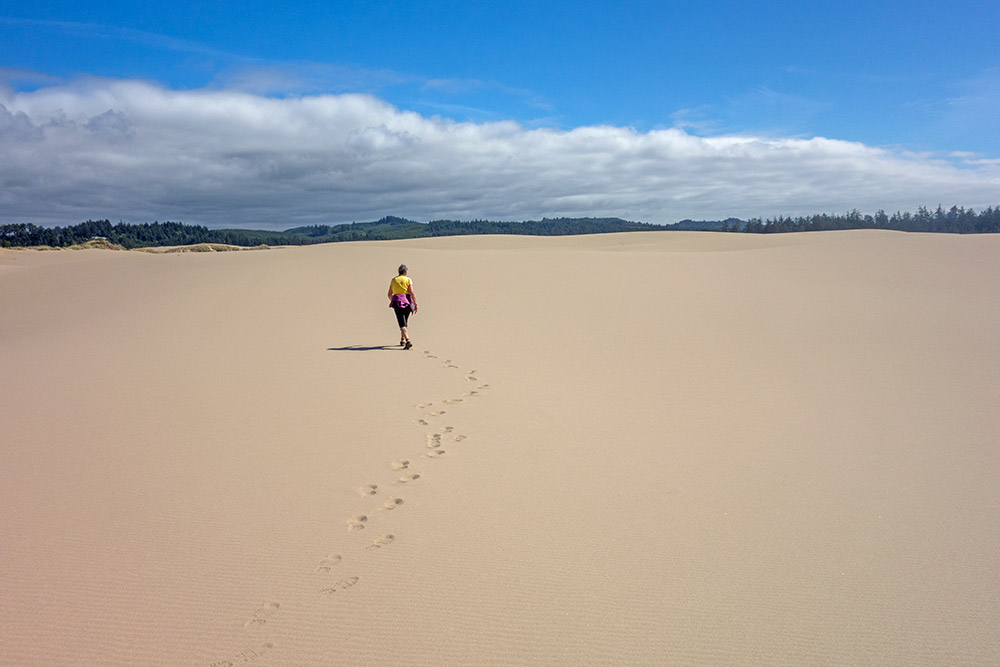
ReplyDeleteGlad you finally made it back. That was a nice picture of Merikay and her footprints on the sand! I do love the beach!
Gee, another good reason why we don't hike. lol What GPS apps are you using that let you use lat/long readings? I've been looking for one and not having any luck.
ReplyDeleteWe did almost the same thing yesterday and are mighty sore today. I climbed a dune to test it for John (way too hard for him). To get up the dune, I had to pull myself up using the strong seagrass. What a hike for all of us. Good ideas for making sure you get back to the starting place!
ReplyDeleteWe use an app called "GPS Test", available on Google Play free.
ReplyDeleteNow that was an adventure I'm guessing you soon won't forget.
ReplyDeleteHave you tried any of the apps like 'map my walk', 'my tracks' or some such thing. They don't need internet, just gps. I have pre-loaded the area into the tool when I had internet, and then used the app. If you don't preload you'll just get the track with no map data over top. Some of them let you save the track to google docs so you can see it on google maps. Kinda fun!
ReplyDeleteOuch!
ReplyDelete